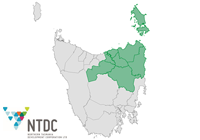
The Northern Tasmania Region comprises eight local government areas: the Break O'Day Council area, the Dorset Council area, the Flinders Council area, the George Town Council area, the City of Launceston, the Meander Valley Council area, the Northern Midlands Council area and the West Tamar Council area. The Region encompasses a total land area of about 20,000 square kilometres. The Northern Tasmania Region includes rural, rural-residential, urban and holiday areas. The Region includes the urban centre of Launceston, the townships of Beaconsfield, Beauty Point, Bridport, Deloraine, Evandale, George Town, Hadspen, Lady Barron (Flinders Island), Legana, Longford, Perth, Scottsdale, St Helens, Westbury and Whitemark (Flinders Island), and numerous small villages and settlements. Half of the population is located in the City of Launceston. Rural land is used largely for agriculture.

NOTE: The land use shown in the map is derived from ABS Mesh Block categories. Mesh Blocks broadly identify land use and are not designed to provide definitive land use. It is purely an indicator of the main planned land use for a Mesh Blocks. For more information please refer to ABS Mesh Block categories.
Transportation Networks
- Bass Highway
- Batman Highway
- East Tamar Highway
- Esk Highway
- Lake Highway
- Meander Valley Highway
- Midland Highway
- Tasman Highway
- West Tamar Highway
- Launceston Airport
- Flinders Island (Whitemark) Airport
- Bell Bay Port
- Bridport to Flinders Island and Cape Barren Island shipping service
Distances
- Devonport GPO 50-300 km
- Hobart GPO 100-400km
Major Industrial Precincts
- Bell Bay (including Bell Bay Aluminium Smelter, Bell Bay Manganese Smelter and Tamar Valley Power Station)
- Invermay (west of Goderich Street)
- Kings Meadows (Tasmanian Technopark)
- Launceston (around Broadland Drive)
- Mowbray (east of the railway line)
- Prospect Vale (around Westbury Road)
- Rocherdale (along George Town Road)
- South Launceston (west of the Midland Highway)
- St Leonards (around St Leonards Road)
- Trevallyn (Trevallyn Power Station)
- Waverley (Waverley Woollen Mills)
- Western Junction (around Launceston Airport)
